 Skip to content
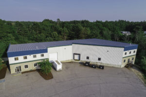
Drones use in Commercial Real Estate
In commercial real estate, first impressions are made online. As competition increases, properties are being marketed with higher expectations—and traditional methods are no longer sufficient. Drone use in Commercial Real Estate has emerged as a powerful solution, offering aerial visuals that enhance listings, build trust, and speed up sales.
Better Listings Through Aerial Photography
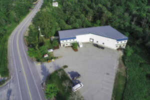
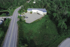
Using drone photography, commercial listings are being elevated with dynamic visuals. Wide-angle views, building perimeters, parking lots, and nearby infrastructure can all be captured in a single flight. These images are helping buyers understand the full scale of a property before ever setting foot on-site. When drone video is added, listings are being remembered—and shared—at much higher rates.
Faster Sales with More Transparency
Buyers are making faster decisions when drone footage is provided. Roof conditions, access points, and surrounding properties can be viewed in detail. By eliminating unknowns, buyer hesitation is being reduced and trust is being built earlier in the sales process. This level of transparency is being expected more often in high-value transactions.
Marketing Costs Are Being Reduced
Drone services are replacing costly helicopter flyovers and static photography. Professional aerial content is being delivered in a single site visit, often within hours. With fewer in-person tours needed, time and money are being saved on both sides of the transaction. Marketing budgets are being stretched further, without sacrificing quality.
Competitive Edge for Brokers and Sellers
Listings with drone footage are consistently outperforming those without. Online engagement is being increased, search rankings are being improved, and potential buyers are spending more time on listings that include aerial video. By adopting drones, commercial brokers are gaining a competitive edge in a crowded digital marketplace.
Site Analysis and Investment Insights
Drones are doing more than just providing visuals—they are supporting real estate analysis. Logistics, traffic flow, zoning issues, and property boundaries are being assessed early with drone imagery. This data is giving investors a clearer view, reducing due diligence timelines and accelerating deal cycles.
Conclusion
The use of drones in commercial real estate is not just a trend—it’s a necessity. Faster sales, better visuals, and stronger buyer confidence are being delivered by drone technology. As competition grows, properties marketed with drone content are standing out and selling sooner.

Don Williams is a seasoned commercial drone pilot and fixed-wing aviator with over a decade of experience in aerial imaging, construction management, and UAS program development. Since 2016, he has led Aerial Imaging Services of Maine, a trusted provider of drone-based solutions for commercial roof inspections, 2D/3D modeling, stockpile analysis, and real estate marketing. Known for delivering high-quality data and cinematic visuals, Don and his team help property owners, developers, and project managers see the full picture—safely, efficiently, and from above.
If you would like more information about our services Click here or if you would like to contact me directly 207-841-2078. If you would like to see some of my other articles I will link them .
